This has been the venue for our meetings to date, and was also the rendevous point for our Glen Lochay surveying in 2007. Killin is famously in Stirling Council area and has a Stirling postcode, but is most definitely in PERTHSHIRE. Try telling people there anything different!!
Wednesday, 30 April 2008
Tuesday, 29 April 2008
Highland Perthshire
This was the view this morning looking across the upper Tay valley towards Pitlochry. The picture is taken from the Crieff Road above Aberfeldy. It is perfectly still, the smoke is going straight up in to the air, and there is mist hanging around everywhere.
Scottish Native Woods have their main office in Highland Perthshire, which is also their original place of birth, a great deal of native woodland expertize being available in this one small area. Hence all the nice trees!!
Click on the images if you would like a closer look.
Schiehallion from Aberfeldy
Highland Perthshire Video
This is a scan of the view that you get from the Crieff road above Aberfeldy. It is a spectacular view in nearly all weather conditions. Today, it was just quiet and misty with the birds twittering away..............
Another iconic TWCP species, Fresh Water Pearl Mussels
This is an impressive but an unfortunate ( and dead) specimen of fresh water pearl mussel, which must have been dislodged by floods in February this year. There had been a flood two days before, the mussel is fresh, but had not yet been found by the birds. The Tay Special Area of Conservation lists Fresh Water Pearl Mussel as a qualifying species. This is a mature specimen, the ones pictured below are much younger. We will be adding our records to those already known to SNH.
Young Mussels
Freshwater mussels can live for a long time, but if there is sometime wrong with a river, recruitment of a younger generation is affected, and in some cases, only older specimens such as the one above remain. The mussels in this picture are young, suggesting that the age structure in this particular area is more healthy.
Monday, 28 April 2008
More capercaillie Counting in Highland Perthshire
Out again this morning, this time in an area outwith the TWCP area, but still in Highland Perthshire. This full-length chestnut paling is being used as a more visible deer-proof fence, without the wires, which can so easily kill capercaillie. It is almost impossible to get over this though without impaling yourself, it not being as strong as a normal fence.
This was at about 5.30 am, the rain came on shortly afterwards, and I had to leave at 7am, being thoroughly soaked through. No capercaillie here today, not really expecting any, but signs that they had been here in the past few months.
Sunday, 27 April 2008
Canoe Survey Fun on the Lyon
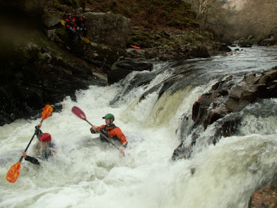
This is our two surveyors, Biscuit & Nellie coming over the waterfall at the Pass of Glen Lyon, during their recent survey trip down the river. Much of the Lyon is not actually that good for canoeing, with a lot of very shallow water interspersed with dangerous rapids in sections. Flow in the Lyon is heavily regulated, with water levels falling to ankle-deep within days of massive floods.
For any children watching, these two guys are professional watersports instructors, and please do not be atempting this at home!!
For more background information on our work, please link to Tay Western Catchments Project.
Waterfall at The Pass of Lyon
Friday, 25 April 2008
Lonesome Pine on the Cononish
Being a native woodland charity, we are obviously interested in native trees. This solitary Scots Pine is in the upper part of the Dochart catchment. The hill in the background is Beinn Odhar, standing at almost exactly 900 metres.
All photographs on this site can be expanded to full screen size simply by clicking on the image.
Glen Lyon Pines
Woods & Waterfalls in Glen Lochay
There are many nice woodland fragments associated with deep inaccessible gullies in these glens. Their age structure and species diversity is usually very good, and the ground flora very rich. But they are often isolated from other woodland.
Very often, you will find attractive little waterfalls like this one in Glen Lochay.
Scattered Fragments
These scattered remnants of birch, rowan and willow are growing on rocky outcrops and other spots inaccessible to grazing animals, and not associated with watercourses as such. Occasionally, we are finding more "interesting" species such as montane willows, aspen or juniper, all of which signify a long history of native woodland at that location. Birch, rowan and willows are all more pioneer species, and can seed in at any time, or have their seed deposited by birds in the case of rowan. There have been a lot of these native woodland fragments in Glen Lochay, and we have been trying to map the ones associated directly with watercourses.
Thursday, 24 April 2008
The River Lochay
We started our project in 2007 with a pilot survey in Glen Lochay, and have completed about 85% of the watercourses there. We should finish off the Lochay in June this year before progressing to the Lyon. This view is looking down on the middle part of the river. The river itself is dominated by alder trees. The hills are dominated by grassy swards and wet heaths, and bracken is very extensive. There is very little heather moorland in the Lochay catchment, certainly not on the lower slopes, and good quality farmland is very restricted. The sides of the glen are very steep, although the contours usually flatten out after 1200 ft or so. The early part of any walk here is usually pretty tough going, but worth it when you are up there. This was me taking a breather for a minute last summer. As I took the photo I had a phone call from a journalist asking if we would be interested in doing this elsewhere in Scotland. "Yes", I replied. "But let us get this one done first!"
Upper River Lochay
Lochan Chalein
Wednesday, 23 April 2008
Greg Thexton of Forestry Commision Scotland/ BIFF
This afternoon I was out with Greg Thexton of BIFF (Breadalbane Initiative for Farm Forestry), looking at woodland along the lower Lyon. We are gathering woodland management information as part of our survey, and we want to make the best possible use of this information. We were discussing some changes we could make to our survey sheet, gathering more information on volumes of timber that could be thinned. River-side woods are often inaccessible, either through ground conditions or steep slopes, and the timber itself can be low quality. As a result, many such woods are not thinned or managed, and this can have a detrimental effect on watercourses. Also, many local contractors will not invest in suitable equipment, because they do not know how much of this resource might be available. Working with BIFF, we will quantify this resource, and try to facilitate better ways of getting these river-side trees in to some sort of programme of sustainable management.
BIFF is a successful partnership between local farmers in the Breadalbane area, and Forestry Commission Scotland (FCS), who employ Greg to carry out this sort of work. He can be contacted at the FCS offices in Perth, Tel: 01738 442 830.
Timber on the riverside
Many rivers on Tayside are heavily wooded,often on both banks. While a certain % of trees are good for a river, 100% cover for long stretches is definitely a bad thing, creating shade and cooling the water. In this case, non-native sycamore pre-dominates, casts quite a heavy shade, competes with native trees and can potentially help the spread of grey squirels through catchments by providing a source of large seeds. It is however a very good firewood. Alders, although native, cast a dense shade, and they also tend to acidify watercourses because they have the ability to fix nitigen. Many riverside woods consist mainly of alders. Alders are a bad firewood, and the economics of thinning them are often very poor. These are the two most common species on this stretch of the Lyon. Both coppice very well, so if a decent market can be found locally for this material, they will provide a genuine renewable resource. Over a period of time, woodland management along a river should seek to reduce the % of both these species, and reduce the overall woodland cover to, probably, 30-50%. We will be collecting a range of woodland management information during our survey work. If we can quantify the resource available, local contractors will be better placed to invest in suitable harvesting equipment, and local users will be more aware of the likely local supplies. BIFF are well placed to co-ordinate such efforts.
Black Grouse in TWCP Area
One of the interesting species we have been picking up on our survey work has been the black grouse, with three finds in the upper Dochart in unusual places. Last week, a mature black grouse male flew out of a larch tree, just behind me. These are his droppings. The time of year would suggest a lek site in the vicinity. The owner was not aware of any other sitings of black grouse in that area for the past 30 years, and was delighted by the report.
The value of looking at a range of species in a catchment project is that it makes it much easier to secure funding at a later date. Single species projects are difficult to fund. Fish by themselves will not secure the likely investment required for large scale habitat projects.
For more background information on our work, please link to Tay Western Catchments Project.
Black Grouse Habitat
This is classic black grouse habitat, a mixture of open ground and woodland, with scattered broadleaved regeneration in the pinewood to the right. The plantation to the left has partially failed. It is interesting that some of our best wildlife habitats arise when forestry plantings do not establish properly! Diversity in woodlands is very important. Open space should be designed in to all significant plantings, although, as here, mother nature very often decides where that space is best situated. If this plantation had been 100% stocked, the black grouse would probably not be there at the moment.
Caper Counting again
Out again this morning, again in TWCP area. After about an hour of waiting, I thought it was going to be another blank. Then, about 6am, a caper could be heard calling strongly for 2-3 minutes. The sound is unmistakeable when you hear it. After 20 mins of trying to get a bit closer, the caper had gone. The various droppings suggested more than one, but having only heard one, this is the record for that site.
Tuesday, 22 April 2008
Capercaillie Counting in Highland Perthshire
Staff from Scottish Native Woods carry out a range of woodland-related tasks. One of our areas of interests is in management for capercaillie. In Highland Perthshire, we have been carrying out capercaillie lek counts this past few years on behalf of the Forestry Commision and private owners. Caper counting involves going out to known lek sites just before dawn, listening for the distinctive "clicking & popping" call of the males, and trying to count them.
This shot was taken at 5.10am this morning as it was getting light. There is a period of waiting and listening until it is light enough to see what is going on. On this occasion, this was a marginal lek site, and there was nothing present today, and, sadly, after an hour or so of searching, no real sign of any droppings either. Hopefully, that will change tomorrow. This site is within our TWCP area, and indicates the range of interesting species present, all of which are inter-connected to a certain degree. The exact location is not disclosed.
For more background information on our work, please link to Tay Western Catchments Project.
Pine Trees & The Tay
Birds singing at 5am, Highland Perthshire
This is a short video clip of the birds singing at 5.10am in an area of native pinewood. The range of noises is amazing. Sadly, no distictive "clicking and popping "noises from capercaillie today. I will be out again tomorrow morning unless it is very wet.
Monday, 21 April 2008
Loch Tay
This is Loch Tay on a cold April morning. The loch is very calm, and you can see Ben Lawers in the distance, covered in snow. The northern slopes of Ben lawers are in our catchment area. Loch tay itself is not in our area, but we have been getting a tremendous amount of support from the area, especially from among the local fishing clubs.
For more background information on our work, please link to Tay Western Catchments Project.
Loch Tay, Kenmore & Drummond Hill
Here is a little scan I did the other morning, from Loch Tay across to Kenmore with Drummond Hill in the background. The Glen Lyon catchment lies on the other side of Drummond Hill. Kenmore must occupy one of the most picturesque settings in Scotland. Amongst others things, it boasts the oldest hotel in Scotland. The "Mighty Tay" proper is born at Kenmore where it exits the loch. Like everywhere else on the Tay, there always seem to be a few ducks sitting around!
Thursday, 17 April 2008
Nelly & The Otters
We are using this incredible piece of footage to launch our TWCP blogspot. Nelly (Neil Wardman) is pictured having his lunch by the side of Loch Dochart, when, after hearing some noise in the water, these two young otters suddenly appeared, ran up to Nelly, played around for 10-15 seconds, and then disappeared. Our other surveyor on the day, Richard Turner (Biscuit) shot this video on his mobile phone. Nelly is trying not to move in case he scares the otters away, and hence justs sits there smoking his cigarette.
These are real, wild, Scottish otters. Biscuit and Nelly where surveying the river and loch by canoe, and were resting in an area not usually visited by humans. Maybe this is why the otters seem so relaxed.
We will be updating this site throughout the summer with all interesting video footage that we take, and with two people out every day, we hope to establish a huge archive of material for future reference and enjoyment. We hope that you enjoy this site.
Please have your speakers on for this video, and you will hear the otters squeaking to each other.
For more background information on our survey work, please link to Tay Western Catchments Project.
THE TAY WESTERN CATCHMENTS PROJECT
The TWCP was set up by Scottish Native Woods in 2007, and is guided by local landowners, the Tay Ghillies Association, the Tay Liason Committee and the Tay District Salmon Fisheries Board. It is a catchment scale project looking at the three glens of Lochay, Lyon and Dochart. Phase 1 is undertaking a thorough survey of over 1000 miles of rivers and watercourses, about 60% of which are high up in the hills.
We will be re-starting our survey efforts in late May, and plan to post videos and pictures here on a regular basis, hopefully daily. There will be a limited amount of material added between now and then, hopefully 2-3 times a week. We hope that you will save this blogspot to "Your Favourites", and we will seek to keep you updated with excellent photos and videos, as things happen. Please pass on a link to your friends.
Regards,
Victor Clements
Highland Perthshire Area Manager, Scottish Native Woods
The DOCHART CATCHMENT
The following photographs have been taken on the Fillan and Dochart rivers, some from a canoe survey carried out in February this year. Following the photos, there is a selection of video clips within the same catchment.We have surveyed about 20 % of the Dochart to date, and hope to restart here in July, after we have finished the Lyon.Photos and videos from the Lyon follow this section from the Dochart. You can scroll down to find them.
All photographs on this site can be expanded to full screen size simply by clicking on the image.
Kirkton Glen
This is Kirkton Glen, a remote upland glen, drained by the Allt Auchtertyre (pictured) which enters the very top end of the Fillan beside the Holy Pool.
It always seems to be raining up here, the hills are very steep and unforgiving and we were glad to get this area finished. Kirkton Glen is managed by the Scottish Agricultural Colleges, and hosts several interesting experimental sites relating to sheep grazing and native woodland establishment at high levels.
The Allt Auchreoch
Coille Coire Chuilc
The River Cononish
Tyndrum Block
This is a view up the Fillan towards Tyndrum. The block of coniferous forestry running up the hill to the right is the Tyndrum block, a Forestry Commission plantation that cannot be harvested because modern harvesting machinery cannot cross the railway line that runs beneath it. Being in such a prominent location, just behind Tyndrum and in the Loch Lomond & Trossachs National Park, this is going to be a big issue in the future. We are picking up some significant issues like this in our survey work, and, in this case, we would like to strengthen the case for addressing this issue sooner rather than later.
The River Fillan
Loch Dochart
Habitat Work in Progress
Many people blame forestry for problems with rivers, and , indeed conifers planted right up to watercourses are not a good idea, from a number of points of view. Here, next to the Dochart, the owner is felling a conifer wood from the riparian zone, and replanting with native broadleaved species, more suited to the location. In this case, the economics of doing this are sensible, government and National Park policies encourage such changes when the opportunity for felling arises. The Dochart catchment is very heavily afforested, and encouraging more of this type of work will be very important.
Little Dipper
Otter Tracks
Answer
It is actually two animals, an otter (top print), being followed by a fox (bottom print). Both animals have been passing along this bank of sand on Loch Dochart within a few hours of one another.
Two in a canoe
The following video footage has been shot by Biscuit & Nelly (above) from their canoe. Three different canoes had to be used to cater for the different water conditions throughout the Dochart system. This one was fine in deeper water conditions, but a more shallow kayak was also used for the very shallow sections of the river. Another one, the "duckie" was used where some sections had to be by-passed and the boat had to be carried short distances.
Fillan & Dochart Videos
Here are a few videos of the Fillan and Dochart rivers, and going through the two lochs on the system. The videos are generally going DOWN the system, from the Fillan down to Loch Tay, which took about two and a half days to survey by canoe.This first footage is on the Fillan, which is a very slow moving river in parts. In fact, in many areas, you will struggle to see the water moving at all. In this footage, our surveyors have come across a sheet of ice and are having a bit of fun breaking through it.
The River Cononish
This is the river Cononish, which becomes the Fillan about a mile further downstream from this point. The Cononish really is the recognized headwaters of the Tay. At some point later this summer, we will get right up to the source, and we look forward to providing you with footage at that point. To the side of the river lies Coille Coire Chulic, or CCC for short, one of the most southerly native pinewood remnants in Scotland, and a beautiful spot. See above for a full description.
On Loch Dochart
This is Loch Dochart, the smaller of the two lochs on the Dochart system, to the west of Loch Iubhair. The river Fillan flows in to Loch Dochart from the west, a short stretch of water leads through to Loch Iubhair, where the River Dochart itself then begins. You can see here the little island in the middle of the loch. Conditions on the loch are quite calm.
Source of The River Dochart
This is the start of the River Dochart, having just emerged from Loch Iubhair, the bigger of the two lochs on the Dochart system, to the east of Loch Dochart. The bridge in the footage leads across to Lochdochart House. The river Dochart leads down to Killin and on to the Tay.
The end of The Dochart
This is the guys just tootering around among the reeds at the end of their journey down the Dochart, with some ducks and other water fowl in attendance. It is very, very quiet, as you can see. This is where Loch Tay begins. The river Tay itself then starts at the eastern end of the Loch.
Confluence with The Lochay
At the end of a long journey down the Fillan and Dochart, taking about two and a half days, we reach the end of the river, where the Dochart meets the Lochay, before merging with Loch Tay. Richard Turner (Biscuit) is doing the voice-over. The sun was exceptionally bright, hence he is shooting this video through his sun-glasses.
Bridge at Falls of Dochart
Killin is best known for the spectacular Falls of Dochart, which is always worth a visit, whether the river is in near-flood conditions or on a quiet evening in summer. This video is shot below the bridge, in fairly high water conditions, hence the noise on the footage. You might want to turn the volume down a bit on this one.
The River Dochart
There are a number of different flow conditions on the Dochart, ranging from rapids and extremely fast flowing sections, to almost dead calm (see below). The section here shows a nice moderate flow, with extensive areas of spawning gravel and nice fish habitat. The previous day, the Dochart was in full flood, but came back to this level extremely quickly.
Tuesday, 15 April 2008
A Quiet Spot on The Dochart
This is a very quiet spot, river is very slow moving, birds singing away. just above Ledcharrie Farm on the Dochart. makes you want to stay for a while!!
THE GLEN LYON CATCHMENT
This section is devoted to Glen Lyon, and comprises a mixture of photographs and videos. In both cases, posts are ordered from the bottom of the glen at the Pass of Glen Lyon, moving upwards towards Loch Lyon at the top of the glen.
The river Lyon extends for some 27 miles from the dam at Lubreoch to the confluence with the Tay, being reputedly the longest, loveliest and loneliest glen in Scotland. It is also referred to as the "Crooked Glen of Stones"
Enjoy this little tour of the River Lyon
The river Lyon extends for some 27 miles from the dam at Lubreoch to the confluence with the Tay, being reputedly the longest, loveliest and loneliest glen in Scotland. It is also referred to as the "Crooked Glen of Stones"
Enjoy this little tour of the River Lyon
Waterfall at the Pass of Glen Lyon
Lower Lyon 1
Upper Lyon 1
Upper Lyon 2
A few more Lyon Videos
Here are 3 short videos just to illustrate that although this is a really beautiful river, as demonstrated by previous photographs, it can also be a very powerful and scary one. These three videos were taken by Richard Turner (Biscuit) who along with Neil Wardman (Nelly) surveyed the length of the Lyon for us in a canoe. As well as allowing us to do this faster than walking, it also allowed us to get some good footage from the middle of the river.In December 2006, there was a massive flood on the Lyon which caused a great deal of damage, and contributed to a particularly bad flood in Aberfeldy. This is one of the few stretches of the Lyon which is near to the main glen road, and the damage is very evident. This stretch of the main road will obviously be vulnerable to future flooding damage as well, bit of an issue for the council perhaps if the main road to the glen gets cut off!! A considerable amount of manpower was expended putting this right again. Erosion took place right up to the edge and underneath the tarmac.
Erosion Scars
There are many long stretches of erosion like this on the Lyon, again emphasizing how powerful a river this is. A river needs a certain amount of erosion to recharge itself, and in this photo, we can see that there is a very good supply of spawning gravel being eroded from the base of this scar, and that is good for the river. The soil on top of this will input fine sediment to the river and that is not so good, as this can smother otherwise good fish habitat, especially spawning gravel. A certain amount of this is natural, and does not do much in the way of damage, and this type of erosion can provide homes for birds like sand martins. We are logging all these erosion scars, some of which we might be able to stabilize, maybe by fencing or tree planting. If the survey is repeated in future, we will be able to see if this sort of thing is increasing or not. We might expect it to increase as winter rainfall increases and floods get more common. We will probably try to commission a report to give some guidance on this type of issue.
Cashlie
Subscribe to:
Posts (Atom)